Monday, December 31, 2007

Happy New Year


Hi folks, and Happy New Year to you all.

We left harbour at 2pm local time. After 10 hours of navigation, the state of affairs is the following: heading 190 degrees, speed 12 knots calm(ish) sea, rapidly clouding over.

I was told to expect the Astrolabe to roll a lot, and I can confirm that it does. The sea is pretty calm, yet we are rolling constantly between 10 and 20 degrees. I have not yet felt seasick, luckily.

We have been playing games on the aft deck to train our inner ear: running round the helipad, balancing on one leg, standing still in a tai-chi position etc. All this ponctuated by running to the side to gawp at dolfins that come every now and again to play.

We are an hour away from midnight, the sun has set, and champagne is waiting for us in the mess. Happy New Year to you all!

Astrolabe day 1


Hi folks!

Here we are on board the Astrolabe. It is a sunny day in Hobart, Tasmania, and we spent the morning strolling around the harbour. It is yachting season, and there are many great ships that have just finished the Melbourne to Hobart regatta. Some of these look like they cut water really well.

We boarded last night, our fist night of sleep in a horizontal position for three days (long haul flights and all that). Luckily for us the Astrolabe had not finished loading its cargo, so we spent the night in the harbour. No seasickness.

We will be departing in a few hours for the open sea. Large seas are forcast right for New Year's dinner... I'll keep you posted on how that goes.

[No photo attachments are permitted on either outgoing or incoming mail to the ship, so there will be no pictures with my posts until I reach dry land again.]

Saturday, December 29, 2007

Visiting Hong Kong

As you can see from the above photo - taken at the airport shuttle station in central Hong Kong - we did make it out of the airport and into the city after all. It took us some time (over an hour) to figure out how to pass from the Cathay Pacific lounge in the departures area to the outside world. A hint for those who would want to do the same on future trips: go to the Cathay Pacific transfer desk, and ask for a special form. This form will allow you to backtrack your way through the security controls, and get to Hong Kong immigration. From there on it is easy and relatively fast to get to the airport shuttle and then the street.

Hong Kong is full of contradictions, most vividly exemplified by the juxtaposition of ultramodern skyscrapers (see below for an example) with archaic colonial era buildings, and bamboo scaffolding (see even further below). The transport system is a similar hodgepodge of state of the art automated trains, red and white Toyota taxis, and ancient busses, trams and lorries. The city is at once very rich and very poor.


We have now returned to the airport, after six hours of sightseeing, happy, tired and jet-lagged. I am now looking forward to a few hours of rest before our next long-haul flight to Melbourne, Australia.

-----
Keep up to date with the latest developments at http://sismordia.blogspot.com

Greetings from Hong Kong International Airport

After a long but rather uneventful first leg of our journey, here we
are at Hong Kong International Airport, at the start of a 15 hour
layover before our next flight. The conditions are rather luxurious
compared to what I've been used to. It helps that IPEV (the French
polar institute) organized airline lounge passes for us all.

There are 28 of us currently lounging around the place, all from
different institutes, all going to Antarctica to do different things.
As you might expect from a crowd of scientists and nerds, the
proportion of us tapping on laptop computers as I write is
non-negligible. I guess a nerd remains a nerd even when traveling.

It is sunny here, and quite warm (20C at 9am). Some of our group are
trying to figure out how to manage to leave the airport and do some
sight-seeing in town. If it turns out to be possible, I will probably
do that to, otherwise I'll take advantage of the relative comfort of
the Cathay Pacific lounge to catch up on the sleep I did not get on
the plane.

That's all for now, folks!

Thursday, December 27, 2007

Expedition Planning #14 : Tomorrow is the day

The waiting is over. This is the last expedition planning post. Tomorrow at 5:45 am the expedition starts for real.

I shall post when I can, taking advantage of the email-to-blog feature used in this post. As I expect to have access only to text-based email, my posts may not be nicely formatted. Please bare with me. My colleague JJL has agreed to become a co-author on this blog and to fix the worst of the formatting during my absence.

I shall not be able to access the web much if at all, so expect me not to be up to date with what's going on in the blogging world. This also means I shall not be able to read your comments in real-time, though rest assured that I shall read and reply to them upon my return.

I have been looking forward to this expedition for so long! The expedition has two aims: continue work on the permanent seismic station at Concordia (code name CCD), and start the CASE-IPY experiment by deploying three prototype autonomous seismic stations. JY and I will be working flat out from the moment we set foot at Concordia in early January, in order to complete everything on our ambitious to-do list. Not so much, though that I won't be able to savor the experience of being in Antarctica, and share it with you all.

Best wishes to all for the up-coming New Year!

[Photo credit Philippe Noret - AirTeamimages]
-----
Keep up to date with the latest developments at http://sismordia.blogspot.com

Wednesday, December 26, 2007

Expedition Planning #13 : Astrolabe position update


D-Day minus one and a bit: the latest GPS readings have the Astrolabe at 250 nautical miles (290 miles or 560 km) from Hobart (see image above).

-----
Keep up to date with the latest developments at http://sismordia.blogspot.com

Tuesday, December 25, 2007

Expedition planning #12 : flight plans

The tickets have been purchased and sent to us, so there should be no further modifications to our departure date of December 28th (in two days' time).

Itinerary on the way out : Strasbourg - Paris - Hong Kong (16 hour layover) - Melbourne (6 hour layover)- Hobart. Itinerary on the way back : Hobart - Sydney - Hong Kong - Paris - Strasbourg (with no significant layovers anywhere).

Our expected arrival date back in Strasbourg is February 19th.

My next task: packing!

Antarctic craziness: marathons at 80S

As I say in my blog description (orange box at the top of the sidebar):

You'd be surprised how many crazy souls are out there...
You don't get much crazier than this: running a marathon and/or a 100km trail at 80S. These marathon runs are aimed exclusively at adventure runners who can shell out the $15k registration price to participate in the only foot-races on the Antarctic continent. They can choose between a 26-mile marathon or an 100km (62 mile) ultra race over snow and ice, at an altitude of 3000ft, with an average temperature (including windchill) of -20°C, and the possibility of strong Katabatic winds. Not for the feint of heart (and definitely not for me!).

The 3rd edition of these races was held on December 20th. The marathon was won by Marc de Keyser from Belgium, in a record breaking time (4h, 42min, 32sec). Only two out of the ten runners who had entered for the 100km ultra race completed the run. Cristian Schiester from Austria took the title in just under 20 hours, while Susan Holliday from Great Britain became the first woman to complete the distance in Antarctica in just over 22 hours. You can find all the results and more information on the races on the Antarctic Ice Marathon website.

Monday, December 24, 2007

Merry Christmas, folks!


Merry Christmas and a Happy New Year !

It's that time of year again, the decorations are up, the cards are sent, the presents wrapped. This year I have been deficient on the card side, so here is an attempt to make up for things. The picture above was taken in March 2006, on the Southern Indian Ocean island of Crozet, and shows the peaceful co-habitation of Royal Penguins and Elephant Seals. I've turned it into my official 2007 Christmas card.

My thoughts go to my family, with whom I had an early Christmas reunion ten days ago, to my friends and colleagues in Strasbourg, Cambridge, Pasadena and Rome (you know who you are), to our valiant seismic operators at Crozet, Kerguelen, New Amsterdam, Dumont d'Urville and Concordia, and to the folks spending Christmas on the high seas aboard the Astrolabe (current position shown below).


Best wishes to all !

-----
Keep up to date with the latest developments at http://sismordia.blogspot.com

Sunday, December 23, 2007

Antarctic travel: risky business?

Whether for tourism or research, travel in Antarctica is never free from risk. The same could be said, though, of anything. There is a certain level of risk in crossing a road, hiking a trail, riding a bicycle, driving a car, taking a train or a plane. We may or may not acknowledge it consciously, but the risk is there.

Antarctic travel is no different, except for the environmental conditions. Because of these conditions, extra precautions are taken when embarking on any sort of travel, be it on foot, skidoo, tractor, plane or ship. These precautions are designed to reduce the gravity of the consequences of any accident that might occur.

Because of these precautions (be they practice evacuation drills on ships, distance limits on how far from base a sortie can take place, or the obligation to carry radios and spare batteries and to keep in regular contact with the base) the risks involved in any activity in Antarctica are more likely to be acknowledged consciously.

With this acknowledgment comes a certain degree of personal responsibility for one's own safety and the safety of others. Risks are taken, yes, but they are taken with eyes wide open, with all the requisite precautions, and in full knowledge of the potential consequences.

-----
Keep up to date with the latest developments at http://sismordia.blogspot.com

Saturday, December 22, 2007

Expedition Planning #11 : Astrolabe back on the move

Here is the latest position of the Astrolabe. As you an see, it has left Dumont d'Urville and is heading out to the open sea. In five days time it should reach Hobart.

Our departure date of December 28th has been confirmed. We set off on the 7am flight out of Strasbourg. Our route will take us to Paris, Hong Kong, Melbourne and Hobart, where we should arrive on December 30th.

Just a few more small things to take care of, and I'll be good to go.

-----
Keep up to date with the latest developments at http://sismordia.blogspot.com

Thursday, December 20, 2007

Expedition Planning #10 : departure postponed

As you can see from the picture, the Astrolabe is still at Dumont d'Urville. The latest information we have indicates it will set out again on December 23rd.

This means our departure has to be postponed. We'll be flying out on the 28th instead of the 26th. Good news for those celebrating Christmas with their families!


-----
Keep up to date with the latest developments at http://sismordia.blogspot.com

Wednesday, December 19, 2007

Where is the Astrolabe?


The Astrolabe, the ship in the image on the left and our transport to Antarctica, is currently at Dumont d'Urville. You can follow its progress on this web page, or using Google Earth and this kml file.

A little while ago, I wrote a post about the new high-resolution images of Antarctica, called LIMA. They have now been integrated into Google Earth. Here is an image of the current position of the Astrolabe superposed on the LIMA image, in which the ship seems to be navigating on sea-ice. The ship's position is given by its on-board GPS, and is updated regularly. On the other hand, the background image is fixed, and shows the winter extent of the sea-ice. In the height of the Antarctic summer (the summer solstice is two days away), the waters around Dumont d'Urville are usually navigable, though dotted with ice.


As soon as it has finished unloading its cargo, the Astrolabe will go back to Hobart, from where it is scheduled to depart again - with me on board - on December 28th. During the next week, I'll be keeping a close watch on its position !

-----
Keep up to date with the latest developments at http://sismordia.blogspot.com

Tuesday, December 18, 2007

7 things you didn't know about me

Oh dear, I just got tagged! There is a meme going round the Geo-Blogosphere, and I just got hit with it. What is a meme, you ask?

In the context of web logs / 'blogs / blogging and other kinds of personal web sites it's some kind of list of questions that you saw somewhere else and you decided to answer the questions. [The Daily Meme]
Chris over at Highly Allochthonous answered the current meme (which is to list seven things about one's self), and then tagged me to do the same. I've never played these kinds of games before, and I will probably not be able to play while I'm away, so here goes:

(1) Despite loving sailboats and sailing, I get quite seasick, especially when I'm stuck below deck. This does not bode well for the sea crossing to Antarctica.

(2) I decided to do a PhD in Earth Sciences after tagging onto a field trip to Greece. Before then, I was set on a career in Radio Astronomy. From the Heavens to the solid Earth in some sense.

(3) I hate the cold!

(4) As an undergraduate, I learned to fly gliders, though I would probably be incapable of doing so now.

(5) On my reading list for Antarctica: Simon Winchester (in Italian), Garcia Marquez (in French) and Jared Diamond (in English). I'm not doing too well on the reading in original language score (one out of three).

(6) One winter, instead of building a snowman, some friends and I built a snow Loch Ness monster. After that, I could never go back to snowmen, too boring!

(7) Sismordia isn't my first attempt at blogging, but it's the best yet.


OK, I'm done! (I won't be tagging anyone else with this meme - viral blogging can only go so far before it runs out of steam).

-----
Keep up to date with the latest developments at http://sismordia.blogspot.com

Saturday, December 15, 2007

Expedition planning #9b : Back update

Thanks to those of you who contacted me after my last post. After two days of not being able to sit down comfortably, by back is now on the mend. I will be taking extra care not to strain it again before we leave!

Our departure date of Dec 26th has been confirmed. We should be receiving our plane tickets next week.

Posting will be slow over the next few days as I am having an early Christmas reunion with my family. I'll be back soon...

-----
Keep up to date with the latest developments at http://sismordia.bogspot.com

Thursday, December 13, 2007

Expedition planning #9 : What not to do before setting out

If there is one thing I've been conscious of during the past few weeks of testing, packing and shipping equipment, it has been to take great care when lifting heavy objects. With the last of our cases shipped (all 200kg), was quite pleased with myself for not hurting my back by any incorrect lifting.

That is, until two days ago. We had run out of printer paper on my floor, so I went down to the paper-deposit room and stupidly reached over a pile of junk to pick up several boxes' worth... and strained my lower back... Doh!

Not the most intelligent thing in the world to be doing 12 days before departure...

-----
Keep up to date with the latest developments at http://sismordia.blogspot.com

Monday, December 10, 2007

Concordia data acquisition systems


After last week's post on the RefTek digitizer that we shall use extensively for the CASE-IPY experiment, here is a short post on the digital acquisition systems used by the permanent station at Concordia (CCD).

The permanent station uses two digitizers made by Quanterra - Kinemetrics: the Q4120 (big orange box on the bottom shelf) and the Q330 HR (thin orange box on the left of the top shelf) with its external hard disk called a Baler (squat orange box on the right of the top shelf).

They are two very different generations of machines, the Q330HR is newer than the Q4120, but their purpose is the same:

  • to receive analog signals directly from the seismometers (voltage being proportional to the velocity of the ground),
  • to digitize them (turn voltages into bit-counts that can be recorded onto hard-disks or data tapes),
  • and to date them accurately using the time given by a GPS receiver.
The quality of a digitizer contributes greatly to the overall quality of a seismic station. These two are some of the best in their class.

We shall have work to do on both of these digitizers, to configure them to talk to the SeisComP system that is supposed to make it easier to retrieve and archive the data they record. We have prepared for this by setting up identical systems here in our lab in Strasbourg and going through the entire configuration procedure from A to Z. We suspect, though, that going through the procedure at Concordia will be a bit more difficult given both the cold and the lower oxygen level up there!


-----
Keep up to date with the latest developments at http://sismordia.blogspot.com

Small steps count !

In two weeks or so, I will he heading off to do some dubious field experiment in seismology, in a less-than-practical field area. And what do I expect we will learn from such an experiment? What will make the deployment a success?

You may have read previous posts about the objectives of seismological investigation in Antarctica, which mostly involve improvements in our knowledge of its crustal and lithospheric structure, and in our understanding of the inner core. But before we even get to the analysis part, our first great success would be in obtaining data in the first place.

There is so little data available from Antarctica, that any good quality recordings we can make will be valuable. After that, any inference we can make from that data will be icing on the cake. In any case, East Antarctica will not be "solved" during the International Polar Year. We may hit some of our research targets, we may not, but what is almost certain is that we will dig up more questions.

I read a couple of things last week that brought home to me how science advances only one small step at a time, with many findings only appearing after many years of consistent observation. Unfortunately, what today's society wants - and what funding agencies ask for more and more - are predictable results, within two or three years max. It is also getting harder and harder to publish observations without having to come up with some revolutionary interpretation for them. None of this is doing science itself any good.

There are many voices saying similar things. Here are two recent ones:

The author of the Clastic Detritus blog has just defended his PhD thesis on sedimentary geology. Two days before his thesis defense, he posted a piece on how doing science is being like a cog in a giant wheel.

I think people (some scientists included) need to understand how science progresses — through incremental steps over long periods. Yes, there are certainly big leaps (breakthroughs) that are attributed to individuals or small groups of researchers, but those need to be considered within the context of the incremental progression. [...]

Doing science is being a small cog in a giant wheel. Unfortunately, it seems this view is taken rather negatively nowadays. As if being a part of something bigger takes away from individuality. I think that’s a bogus viewpoint. If what I do ends up getting acknowledged beyond my small specialist clique, that’s great! But, I don’t expect it to. I’m not in science for fortune and glory. Surely, I would enjoy the accolades and try to capitalize on it (i.e., get more funding to do more), but visions (delusions) of grandeur certainly don’t motivate me.

In last week's edition of Nature there is a commentary piece by Euan Nisbet on Earth monitoring as Cinderella science. Although the article is focused on the problem of environmental monitoring, much of it is also relevant to solid Earth monitoring such as is carried out by seismological observatories around the world.
Monitoring is science's Cinderella, unloved and poorly paid. Sustaining a long-term, ground-based program that demands high analytical standards remains challenging. Funding agencies are seduced either by 'pure' notions of basic science as hypothesis-testing, or by the satanic mills of commercial reward. Neither motive fosters 'dull' monitoring because meeting severe analytical demands is not seen as a worthwhile investment. At one stage, Keeling was ordered to guarantee two discoveries per year and today, modern research has become a planned journey through set 'milestones' to deliverable destinations.
What should be taken from all this. Only one message: each step counts, and though the big ones may be flashy, it is the small ones that take you where you're going.


Photo credit: photo modified from an image of JĂșlio Reis.


-----
Keep up to date with the latest developments at http://sismordia.blogspot.com

Friday, December 7, 2007

ConCorDia is official


The permanent station at Concordia now officially exists. We registered it this week at the International Registry of Seismograph Stations under the station code CCD (ConCorDia).

Here are the details of the station:

  • Latitude: 75.1065 S
  • Longitude: 123.305 E
  • Elevation: 3240.0 m

This station is part of the French-Italian Concordia project. It is jointly funded by IPEV (F) and ENEA (I), and is jointly operated by EOST Strasbourg (F) and INGV Rome (I).

-----
Keep up to date with the latest developments at http://sismordia.blogspot.com

Thursday, December 6, 2007

Expedition Planning #8 : The last of the equipment is configured

The past two days have been spent getting this funny-looking computer talking to two different machines, copies of the two acquisition systems currently running at the permanent seismic station at Concordia.

The function of this SeisComP computer is to obtain data in real time from recording systems connected to the two seismometers in the Concordia seismic vault, and to retransmit them in a standard format to any number of client machines. We shall install it at the station next month.

This machine is the last of the equipment that needed to be configured for our summer campaign. Yay!

-----
Keep up to date with the latest developments at http://sismordia.blogspot.com

Wednesday, December 5, 2007

International Polar Day - Ice Sheets


Ever heard of International Polar Days? They are a response from the IPY organization to journalists and teachers looking for ways to talk about the International Polar Year. During IP Days, there will be press releases, access to experts and to researchers in the field, images
and videos etc.

The next IP Day will be focused on Ice Sheets, and will occur on December 13th.

Here are some interesting ice-sheet facts:

  • there are only two ice sheets on the planet: one in Greenland, the other (you guessed it) in Antarctica;
  • cores drilled in ice-sheets are records of past climate; the longest record comes from a core drilled at Dome C (near Concordia) by the EPICA project;
  • there is a network of lakes under a large part of the Antarctic ice-sheet; the largest one is Lake Vostok; liquid water is thought to move between them relatively rapidly.
There's a lot more to learn about ice-sheets than is already known. For example: how do they work? How are they formed? What might the effects of global warming be? Are sub-glacial lakes really interconnected? There are over 20 different IPY projects and experiments focused on the ice-sheets. You can find a list here. Some of them, including the Norwegian-US Scientific Traverse of East Antarctica, keep blogs and web journals. As Antarctic field season is getting under way right now, these are worth reading.

Will there be an IP-Day on my kind of research? Probably not. The one that comes closest will be held on March 13th 2008, and will concern the changing Earth, ice, climate, oceans, paleo-climate and Earth history. With all the climate change angles possible on this IP-Day, I fear any mention of Solid Earth history will be pretty feeble, but I'll do my best ...


-----
Keep up to date with the latest developments at http://sismordia.blogspot.com

Tuesday, December 4, 2007

Data acquisition for CASE (and html test)

This post has been re-edited to remove abortive formating from an emailed html post.


The picture above shows a RefTek-130 DAS (digital acquisition system) with all the cables and connections we will be using next month. Except that next month the DAS will not be on a table, with its companion electronics spaced out around it, but crammed in a box with 20cm of insulation on all sides.

The DAS is made by Refraction Technology who are based in Plano, Texas.

All the cables are specially made using silicone instead of ordinary cable covering material. At the temperatures we will be deploying our station at (-30 to -40C) only silicone cables will still be flexible enough to be installed without too much risk of them snapping.

During the winter months (May to October) the temperatures will descend to about -80C. At these temperatures even silicone cables will be stiff and brittle. This means there is no way of moving them without risking breakage, even if it were possible to visit the stations in the dark.

----
Keep up to date with the latest developments at http://sismordia.blogspot.com

Ice-raids, or how stuff gets to Concordia

This is a photo of the IPEV Raid, the ice-convoy that IPEV runs regularly between Dumont d'Urville and Concordia. The convoy takes approximately 10 days to cover the 1100 km that separate these two bases. It carries the hundreds of tons of material and fuel required to run Concordia, and the scientific experiments it supports.

Just over one ton the freight carried by the various Raids of this Antarctic summer is for CASE-IPY: seismometers, acquisition systems, radios, electronics, wooden boxes for station installation, solar panels, masts (for radio antennas and solar panels), and batteries.

The last of our equipment is now on our way to Dumont d'Urville on the second crossing of the Astrolabe (called R1 - counting starts at 0). It should then meet up with the second Raid (called Raid2 - counting starts at 1) at Dumont, and arrive at Concordia by the end of December, just in time for us to unpack it all and start working.

Monday, December 3, 2007

Testing communications options

Having a blog is all well and good, but it would be of little use as
a window on the experience of doing seismology in Antarctica if it
was not possible to update it from down there. The main limiting
factor is internet access. I will be without it for most of the time
I'll be away.

However, all is not lost. I am told that email access is possible,
with emails being exchanged over satellite links once or twice daily,
both during the ship crossings, and at the Concordia base itself.
Blogger provides a feature for sending posts in by email, which I am
using right now to send this post.

This is a text-only email, with a photo attachment that should appear
somewhere in the post. If this format is readable I'll continue with
it, as text emails can be sent from any application. If not, then I
may have to write my mails in html. The next few posts will be tests
of how posting-via-email works in practice.

Now for the photo: this is a picture of one of the means of
transport we will have out there. It is a twin otter aircraft, of
the kind that will ferry JY and me up to Concordia from Dumont
d'Urville. It was taken by another colleague of mine, JB, who went
on several missions up to Concordia before the base was fully built.

CASE-IPY @ AGU


For those of you not in the geophysics loop, AGU stands for the American Geophysical Union, and more specifically for the Fall Meeting of said union, which is held yearly in San Francisco. It is a gigantic meeting, bringing together between 10 and 12 thousand researches in all fields of geophysics.

I usually attend every year (I have missed only one in the past 8 years), but this year getting ready for Antarctica trumped over spending a week in San Francisco. Although I shall not be physically present, there will be some emanation of me in the form of a poster about the CASE-IPY experiment, and about seismology at Concordia in general.

Following are excepts from the poster, freely re-formated for online viewing. Also available are the official AGU abstract and the poster itself.

Scientific Objectives of CASE-IPY

The East Antarctica POLENET network of which the CASE-IPY deployment is a part (station map) will provide unprece dented coverage, allowing us to:

  1. Improve our knowledge of regional crustal structure. Crustal thickness measurements will help trace the boundaries of the units that make up East Antarctica, enhancing our comprehension of the formation and breakup of Gondwana.
  2. Improve our knowledge of regional lithospheric structure. The network will allow lateral variations in the structure of East Antarctica to be imaged at higher resolution than previously possible using both earthquake and ambient noise.
  3. Improve our sampling for inner core studies. Analysis of inner core anisotropy and heterogeneity requires seismic paths nearly parallel to the Earth's rotation axis. The deployment of stations in Antarctica will dramatically increase the number of available paths.


Concordia Permanent Station

Concordia is the site of an experimental permanent seismic observatory station, which has been operational since 2005. The extreme temperatures present at the site (-60 degrees C) imply difficult operating conditions for the seismological equipment. The quality of the data we obtain from this station has been steadily improving as we resolve the technical issues related to working at such low temperatures.


2007-2008 Summer Campaign

This year we shall deploy three prototype stations within a 10 km radius of Concordia. Each station contains a broad-band seismometer, a data recorder, a radio transmitter, solar panels, batteries, heating elements and power control electronics. Each box is protected by 16-20 cm of insulation. Data is telemetered to Concordia once a day. At sundown, when the battry charge falls below a cut-off level, the stations will shut down; they will wake up in the spring, when the solar panels have re-charged the batteries.


-----
Keep up to date with the latest developments at http://sismordia.blogspot.com

Sunday, December 2, 2007

Expedition Planning #7 : The final countdown

D-Day (or departure day) as given by our marching orders is December 26th. While most of you will be sleeping off Christmas and settling in to a relaxing Boxing Day, JY and I will be making our way to Strasbourg airport at the crack of dawn to start our journey to Concordia.

What will we be doing in our last three weeks before departure? It's a classic case of "so much to do, so little time"... We have pared down the remaining tasks to the bare essentials. For me these are:

  • finish configuring the remaining equipment that we will take down there;
  • get an article I am writing with colleagues in the US to a point at which they can move it forward during my absence;
  • brief my colleague JJL (who is also PI on the CASE-IPY project that is taking me to Antarctica) on the current state of a masters project we are co-supervising;
  • get home for an early family Christmas (this also means finding time for early Christmas shopping);
  • buy essentials for the journey and pack my bags.

I would like to say I am calm, collected and efficient right now, and that all this will be done with no stress or panic. The reality is somewhat different. I seem to be going through phases of being entirely with it, calm and efficient, followed by phases in which I feel like I am going in circles and am incapable of doing anything right.

My advice to myself in these cases: breathe! And remember that a journey of a thousand miles starts with one step...

-----
Keep up to date with the latest developments at http://sismordia.blogspot.com

High Resolution Antarctica Images

There has been a lot of buzz around the web recently about new high resolution imagery of Antarctica, called Landsat Image Mosaic of Antarctica (LIMA). LIMA was created by the U.S. Geological Survey (USGS), the British Antarctic Survey (BAS), and NASA, with funding from the National Science Foundation (NSF). Follow the links to read the official press releases from the USGS, BAS, and NASA.

As an example of the quality of images available from LIMA, here is a false-color map of the region surrounding the French permanent Antarctic station Dumont d'Urville. The false-color map incorporates infrared data, which makes it easier to distinguish between ice and snow. Each pixel in the image represents a 15x15m area.


In this image, South is approximately up. You can see the difference between the glaciers sitting behind Dumont d'Urville, and the sea-ice sitting in front of it. In winter the sea-ice completely shuts off the base from the water. As there is no airfield, just a small landing area for Twin Otters and helicopters, all cargo and most people must get to and from the base by ship. The base is accessible only during the summer months, when the sea-ice retreats.

I have been told that the first trips of the year, usually end of October, are the most spectacular. The Astrolabe (the ice-capable ship used to reach Dumont from Hobart in Australia) has to navigate between plates of sea-ice, and some years cannot get to the base itself. In these cases, if the ice-pack is not too wide, people and light cargo is ferried over to Dumont by helicopter. Sometimes the ice-pack is too wide, and the ship has to turn around and go back.

The crossing my colleague JY and I are booked on is due to sail from Hobart on December 28th. We will most likely reach Dumont on the 1st or 2nd of January, at the height of the Antarctic summer. Our chances of finding sea-ice are minimal, but we may if we are lucky get good views of the larger icebergs that will not have drifted too far or melted too much by that time. I am very much looking forward to that!

Friday, November 16, 2007

From Pietro Di Felice #4

This is the final post from Pietro. He will soon be leaving Concordia on his way to a well-deserved vacation !!


Tempo addietro vi avevo scritto di come i treni sembrino fatti apposta per gli addii (non sono parole mie ma di Pieraccioni nel "Ciclone"), di come l'ultimio aereo ci abbia lasciato li in mezzo al deserto bianco, sempre tempo fa (mi sembrano un'enormitĂ  i 9 mesi e mezzo passati da allora)............

Beh, ieri Ăš accadduto l'episodio contrario, Ăš apparso nel cielo, dapprima piccolo piccolo, una macchiolina incolore senza forma, silenzioso, poi pian piano ha preso colori e il profilo s'Ăš ben delineato..... Prima le ali e la coda, poi il vetro nero dietro cui i piloti ci guardavano sicuramente, infine il rombo dei motori; il tutto in pochi interminabili minuti, attesi, desiderati da tanto tempo. Lentamente s'Ăš poggiato sul manto bianco ed Ăš sparito dietro i container che costituiscono il campo estivo per ricomparire qualche secondo dopo dritto davanti a noi!

M'Ăš venuta la pelle d'oca, e vi garantisco che non era per il freddo, peraltro non troppo pungente con i -38°C. L'odore del kerosene bruciato che usciva dai motori me lo sono aspirato a pieni polmoni, tanto per non pensare che fosse un sogno.......potevo darmi il classico pizzicotto direte voi, ma qui in Antartide dopo tutto questo tempo passato in isolamento, ad una quota di 3500 metri il cervello comincia a fare cilecca ed allora si preferisce "sniffare" i fumi dei motori piuttosto che pizzicarsi il culo!!!!!

I piloti che prima erano invisibili dietro i vetri scuri, ci fotografavano come attrazioni locali, quasi increduli che fossimo tutti li ad attendere. Quando la scaletta s'Ăš aperta e sono scesi i primi nuovi arrivi Ăš stata festa, abbracci a non finire e tante parole, grida di felicitĂ ..... come direbbero i "francesi" Ăš stato un "burdell". Piccole cose, forse, ma che segnano e modificano la nostra quotidianitĂ  fatta fin'ora di cicli e routine ampiamente sperimentati in tutti questi giorni di inverno antartico....... sveglia, colazione, lavoro, pranzo, siesta, lavoro, aperitivo, cena, film, dormire! E' iniziata l'estate, yeah!!!!!!

In veritĂ  il primo aereo doveva arrivare il 9 novembre, ma a causa di maltempo sulle stazioni costiere ci sono stati ritardi con gli aerei provenienti dalla Nuova Zelanda e di conseguenza con i nostri piani di volo. Ora la base Ăš in subbuglio, ci si prepara ad accogliere gli altri nuovi arrivi e sarĂ  cosĂŹ fino alla fine del mese di gennaio, quando si ripeterĂ  la storia e i nuovi invernanti saranno lasciati a "svernare" come Ăš stato per noi.

Questi ultimi giorni sono stati un pĂČ frenetici per noi, e di cose ne sono accadute tante. Abbiamo assistito all'ultimo tramonto (oramai abbiamo 24 ore di luce costante), all'ultima luna piena notturna, all'ultima notte di solitudine. Tra le prime cose annoverate c'Ăš stato il mio compleanno,due settimane fa, il primo in antartide, non so se sarĂ  anche l'ultimo, il primo pasto con insalata e frutta fresche, il primo contatto radio con la base Mario Zucchelli dopo l'apertura (01/11), e tante altre cose che non sto qui ad ammorbarvi.....

Comunque questi sono gli ultimi giorni, dovrei andare via da qui intorno al 25 e arrivare in Nuova Zelanda per il 30 novembre e poi via con le vacanze......

Un saluto a tutti
Pietro polare


-----
Keep up to date with the latest developments at http://sismordia.blogspot.com

Monday, November 5, 2007

Antarctica Earthquake : M 5.8 "Casey"


Updated post.

There has been a large earthquake on the Antarctic continent. The USGS report gives the following updated details:

Magnitude 5.6
Sunday, November 04, 2007 at 20:35:36 UTC
Location 67.097°S, 111.316°E
Depth 10 km
Region ANTARCTICA
Distances 95 km SSE of Casey Station, Antarctica

Earthquakes on the Antarctic continent itself are extremely rare. This one is likely to be closely scrutinized by all Antarctic seismologists. Here is a Google Earth picture of the know seismicity in the region around the CASY seismic station at Casey (thanks to JJL for the script used to make this image). The image includes the latest event (left-most on the map).


Here are a couple of pictures of seismograms from CASY station. The first shows the three components of motion (vertical, north, east) for the M5.6 event. The strongest signals are saturated. The second picture shows vertical component recordings of a set of aftershocks of the main event. Although we do not have exact locations of these aftershocks, they occurred at approximately the same distance from CASY as the main event.


-----
Keep up to date with the latest developments at http://sismordia.blogspot.com

Tuesday, October 23, 2007

Antarctica Seabed - the saga continues

After the recent hullabaloo about Britain's submission to the UN Commission on the Limits of the Continental Shelf regarding the seabed attached to its frozen territorial claim in Antarctica, Argentina and Chile have joined the throng (see articles here and here).

It is not surprising that all countries with frozen territorial claims in Antarctica are soliciting the UN-CLCS. The fact that there is a deadline imposed on submissions to the commission leads naturally to a concentration of submissions close to this deadline. In my previous post, I stated that this deadline was fixed at 10 years after the country concerned had signed the Convention on the Law of the Sea (Article 4 of Annexe II of the convention). The articles cited above, however, state that this deadline is in 2009. Why the discrepancy? Quite simply I got my deadlines mixed up (mea culpa!). It seems that the 10-year time-limit had raised many issues with countries unable, often for legitimate reasons, to file their submissions in time, and was therefore modified by the following decision:

The decision provides that, for a State for which the Convention entered into force before 13 May 1999, the date of commencement of the 10-year time period for making submissions to the Commission is 13 May 1999.
You can read more about the details and history of this decision on this CLCS page.

Given the 2009 deadline, both Chile and Argentina are well within their rights in submitting their own claims to the Antarctic seabed. None of these claims should actively be considered by the CLCS while the Antarctic Treaty is in force. Should the time come, any decision on the British, Chilean and Argentinian claims will most probably be dependent on resolution of their overlapping claims to the Antarctic continent itself.


-----
Keep up to date with the latest developments at http://sismordia.blogspot.com

Saturday, October 20, 2007

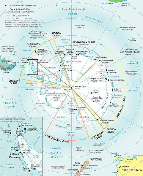
Who owns Antarctica?

Update: since writing this post, Chile and Argentina have reacted to the British submission to th UN Commission on the Limits of the Continental Shelf by announcing they will file their own claims. Read all about it in this follow-up post.

Who owns Antarctica?


This question is one of many Antarctica-related questions my colleagues and I asked visitors to our International Polar Year stand at the recent Science Fair (Fete de la Science) held last weekend. It was of course a trick question, because no-one owns Antarctica. All territorial claims were frozen by the Antarctic Treaty, which guaranteed the continued use of Antarctica exclusively for peaceful ventures, and the freedom of scientific investigation and cooperation in Antarctica.

So imagine my surprise the following Wednesday, when this article from the Guardian newspaper appeared: Britain to claim more than 1m sq km of Antarctica - Move would extend UK oil, gas and mineral rights.

Here are some quotes from the article (ellipses are my own):

The United Kingdom is planning to claim sovereign rights over a vast area of the remote seabed off Antarctica [...] The submission to the United Nations covers more than 1m sq km (386,000 sq miles) of seabed, and is likely to signal a quickening of the race for territory around the south pole [...]

The claim would be in defiance of the spirit of the 1959 Antarctic treaty, to which the UK is a signatory. It specifically states that no new claims shall be asserted on the continent [...]

The Foreign Office [...] has told the Guardian that data is being gathered and processed for a submission to the UN which could extend British oil, gas and mineral exploitation rights up to 350 miles offshore into the Southern Ocean. [...]

The Antarctic submission reflects the UK's efforts to secure resources for the future as oil and natural gas reserves dwindle over the coming decades[...]

The article raised two troubling questions in my mind: how is such a claim compatible with the Antarctic Treaty System? and is the Antarctic seabed legally exploitable? Before getting onto my high horse about this claim, I needed to look more closely into the Antarctic Treaty itself. The best source of information I could find was the Antarctic Treaty Secretariat, where I re-discovered most of the facts described below.

The Antarctic Treaty deals with the issue of sovereignty in Article IV, essentially maintaining the status quo of 1959 with regards to territorial claims and their recognition :
No acts or activities taking place while the present Treaty is in force shall constitute a basis for assenting, supporting or denying a claim to territorial sovereignty in Antarctica or create any rights of sovereignty in Antarctica. No new claim, or enlargement of an existing claim [...] shall be asserted while the present Treaty is in force.

Note that the Treaty does not require the countries with territorial claims made before signature of the Treaty to renounce them. The British, Australian, New-Zealand, French, Argentinian, Chilean and Norwegian claims were therefore frozen in 1959. [Note that to further complicate matters, the Argentinian and Chilean claims overlap with the British claim].

If no new territorial claims can be made or extended, what is this possible submission to the UN by the United Kingdom about? The submission would be to the UN Commission on the Limits of the Continental Shelf (CLCS). This commission judges claims on the limits of a country's continental shelf, which in turn affect the definition of its territorial waters. According to the Convention on the Law of the Sea (CLOS), claims to the CLCS should be submitted within 10 years of its entry into force for that country. As the UK signed the convention in 1997, should it wish to submit any claims, it should do so before the end of 2007. Hence the submission described by the Guardian article.

Something that was not mentioned in the Guardian article, but was brought to my attention by the Antarctic Treaty Secretariat site, was that Australia and New Zealand both submitted similar claims regarding the continental shelf adjacent to the regions of Antarctica over which they held territorial claims before 1959. The Australian claim was submitted in 2004 (Australia signed the Law of the Sea in 1994), while the New Zealand claim was submitted in 2006 (New Zealand signed the Law of the Sea in 1996).

In order to allay any concerns about the Antarctic Treaty, Australia requested that the CLCS not take any action for the time being on its Antarctic claim. The Guardian suggests the UK should make a similar request:
Ministers will have to decide under what terms the application to the UN would be made. One possibility might be for the UK government to lodge a legal claim with the UN's commission on the limits of the continental shelf and effectively park it for consideration at a future date.
As for any remaining environmental concern about future drilling off the coastal waters of Antarctica, the Protocol on Environmental Protection, an addition to the Antarctic Treaty, specifically prohibits all activities relating to the Antarctic mineral resources except for scientific research (Article 7).


What are my conclusions after all this? Firstly, that as far as I can see the UK will be doing nothing illegal or morally wrong by submitting its claim to the UN, though it will most probably have to find an agreement with Argentina and Chile given their overlapping claims to Antarctica. Secondly, and more importantly, that at some time in the future, and preferably within the next 20 years, it will be necessary for the international community to put some order into its conventions and treaties, and to decide how it intends to balance national interests with environmental issues.


Update: since writing this post, the following posts/articles have come to my attention:

-----
Keep up to date with the latest developments at http://sismordia.blogspot.com

Friday, October 19, 2007

Japan - Pioneering Earthquake Early Warning

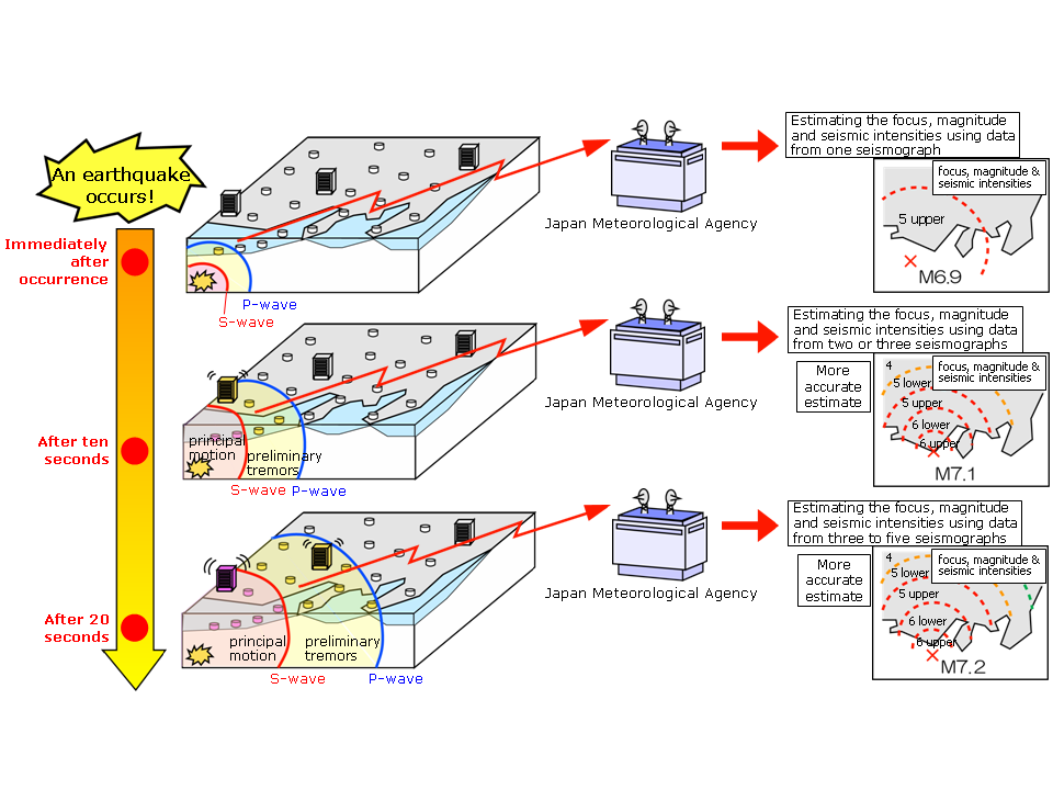
The Japanese Meteorological Agency has been testing an Earthquake Early Warning system for some time. Up until recently, the warnings were received only by certain agencies and infrastructures such train networks. As of October 1st, the JMA has started distributing these alerts to the public at large, via radio and TV.

The system provides estimates of the seismic intensities and expected arrival time of strongest motion. These estimations are based on fast determination of the location and magnitude of the earthquakes using data observed by seismometers near the epicenter.


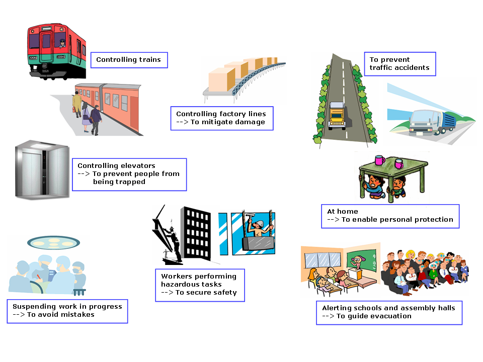
Earthquake Early Warning reduces earthquake-related damage by giving time to act in preparation to the shaking, for example by slowing down trains, controlling elevators. Now that warnings are received by the public, they will enable people to protect themselves in the appropriate manner for the location they are in.

The decision to trigger an earthquake warning is taken automatically by the EEW system, based on the information it receives from the seismic stations. There is a trade-off inherent in all alert or warning procedures, between the promptness of an alert and its accuracy: simply put, it takes time to get enough information to make an informed decision, but an alert is only useful if given sufficiently in advance.

The JMA list the following inevitable limitations to the EEW system, which have to be taken into account by the users:

Timing
The window of time from the announcement of an Earthquake Early Warning until the arrival of the main tremors is very short, i.e. a matter of seconds (or between several seconds and a few tens of seconds). In areas that are close to the focus of the earthquake, the warning may not be transmitted before strong tremors hit.

False alarms
When using data from only one seismograph, false Earthquake Early Warnings may occur as a result of noise from accidents, lightning or device failure.

Magnitude estimation
There are limits to the accuracy of estimating magnitude, especially for large earthquakes. It is difficult to separate earthquakes and provide accurate warnings when multiple earthquakes occur almost simultaneously or in close proximity to each other.

Seismic intensity estimation
There are limits to the accuracy of estimating seismic intensity by statistical attenuation formula, as well as limits to the prediction of land surface amplification.
You can read more about the EEW system on the JMA webpage, where you can also find these two leaflets explaining how the system works, and how to react to a warning.


Call for comments: Are you living in Japan, or do you know people who are? Have you (or they) had to react to an Earthquake Early Warning yet? If so, please let me know how it worked, what went through your mind, what you did to prepare for the shaking, how you felt afterwards.

-----
Keep up to date with the latest developments at http://sismordia.blogspot.com

Thursday, October 18, 2007

Expedition planning #6 - The final touches

First of all, apologies to my regular readers for dropping out on you with no warning. It has been over a month since my last post, and the time has flown.

In this time I/we have:

  • sent a malfunctioning acquisition system back to the supplier for repair, which action engendered a comedy of errors with our not-to-be named, least favorite customs broker;
  • tested all hardware being sent to Antarctica every which way possible short of destruction testing;
  • designed, written, tested, debugged, re-designed, re-tested the software which should enable us to have access to the data from our temporary field stations with some regularity;
  • traveled to Rome and back to coordinate the summer and winter campaigns with the Italian colleagues with whom we run the Concordia seismic observatory, and with those who are trying to get their own funding for an International Polar Year experiment;
  • spent an evening on the ice at the local ice-rink as part of a nation-wide IPY-themed initiative, La Nuit des Chercheurs - Researchers' Night, during which we entertained skaters with our tales of Antarctica, and counted the number of their spectacular falls by recording them on our portable seismograph;
  • spent two days teaching the 2008 Concordia station chief, Jean-Francois Vanacker, all about the observatory station there, and what he needs to do to make sure it keeps running (he's a great guy, we're confident he will do an excellent job);
  • been to see: a radiologist for a chest X-ray and lung capacity test; a cardiologist for an electrocardiogram; my dentist to have a wisdom tooth pulled; an clinical analysis center to have a full suite of blood tests; the university doctor for a general checkup; all this so we can be certified fit enough to work in Antarctica;
  • spent one half day each chatting to kids, parents, teachers, and other generally interested punters at another outreach initiative, La FĂȘte de la Science - Science Fair, which was - in a fit of originality - also geared towards the International Polar Year;
  • packed nearly all our equipment first in sealed plastic wrap (to guard against humidity followed by Antarctic temperatures, the combination of which leads to things being frozen solid), then in aluminum cases for shipping out to Hobart by air-freight (no cardboard allowed, as freight has to be sprayed before entering Australian territory)...
... and much more that has slipped my mind for the time being, or maybe for good!

I will make no promises - for what good is a promise if I am forced to break it - but I shall try to post more regularly now the most time critical expedition planning is over, and I can breathe relatively freely once more.

-----
Keep up to date with the latest developments at http://sismordia.blogspot.com

Saturday, September 15, 2007

Expedition planning #5 : Marching Orders

It is now official: this Antarctic summer's expedition is on. We - my intrepid collaborator JY and I - received our marching orders last week.

They consist in a departure date (December 26th), a 40-page document containing information about our journey and about the two bases we will visit / sojourn at (Dumont d'Urville and Concordia), a list of clothing we will be issued with (some pretty cool warm stuff), and lots of medical forms for us and our doctors to fill in.

Next on our list - together with building / testing / fixing the equipment that must be shipped out by the end of the month - is getting doctors' and dentists' appointments to make sure we're physically good to go.

-----
Keep up to date with the latest developments at Sismordia - Seismology at Concordia

Friday, September 14, 2007

From Pietro Di Felice #3

Here is yet another message from Pietro di Felice (message orignally sent Sept 5th - my apologies for late posting). It has been pretty cold at Concordia lately, with temperatures going down to -80C.  Perfect temperature for an Antarctic sauna, don't you think? 

Miei cari amici,
finite le vacanze (sempre per chi le ha fatte ben inteso)?!?!?!

So che la calura a Roma e dintorni ancora  si fa sentire,  dovreste sentire che freschetto che fa qui. Malgrado l'arrivo del sole il mese di settembre è sempre il più freddo e le temperature raggiungono i record stagionali. Ieri l'altro abbiamo registrato il picco di -81.9°C senza vento, col vento si scende oltre i -100°......... I metereologi sono "fiduciosi" che si possa comunque scendere al di sotto queste soglie (sono pazzi questi metereologi).

Detto tra noi io non vedo l'ora di avere un pò più di caldo cosa che dovrebbe avvenire dalla fine del mese in poi. Comunque se continua così tentiamo di entrare nel "club 300"... che cos'è direte voi?!?!?!?? è una delle tante cose strambe "inventate" dagli americani che stanno qui al polo, più a sud di noi, nella stazione di South Pole esattamente al polo sud geografico.  Club 300, deriva dal fatto che il tutto va fatto quando la temperatura dell'aria scende al di sotto dei -80°C che nell'unità anglosassone del Fahrenheit è di - 300°, di qui il nome club 300.......... Vi terrò aggiornati!!!!!!

Insomma in parole povere tutto quello di cui si ha bisogno è una sauna........ e dove la prendi una sauna in Antartide?!?!?!? beh voi non ci crederete ma tutte le basi al Polo ne hanno una, per lo più sono baracche di legno non più grandi di 2 metri per 2 metri, dentro cui si ficca un braciere elettrico e lo si manda a "tutto gas"!!! anche da noi c'è, dall'esterno sembra, anzi è davvero una baracca di legno, e l'interno non è migliore, però funziona. Insomma, si porta la sauna a temperatura elevata, ci si infila dentro come in una normale sauna...... Poi, quando si è ben caldi, si indossano le scarpe e si esce nudi come mamma c'ha fatti e si fa un giro della base il più in fretta possibile.

Le giornate si vanno piano piano allungando, le ombre sul terreno invece si accorciano di giorno in giorno. I colori sono sempre accesi, l'arancio dell'alba si porta dietro tonalità giallo verdi e celi di un azzurro incontaminato (sempre che i fumi dei nostri della nostra centrale non decidano di sparpagliarsi a ventaglio sulle nostre zucche). La sera poi, verso le 18 il sole termina la sua corsa sul carro di Apollo e le tenebre tornano padroni del tempo e dello spazio intorno a noi. Ecco che allora miliardi di occhi lucenti appaiono e ci guardano dall'alto immobili. Gli astronomi in base allora iniziano a lavorare, gli ultimi mesi di fatica visto che poi verso l'inizio di ottobre, con l'avvicinarsi dell'ultimo tramonto le stelle smetteranno di comparire e loro andranno in "ferie".

[...]

A presto e buona giornata a tutti. Vi aspetto

Pietro polare


-----
Keep up to date with the latest developments at Sismordia - Seismology at Concordia

Thursday, September 13, 2007

Antarctic blog posts review #3

If you've been wondering why it's been so long since my last blog post review, I can give two reasons: not that many Antarctic posts, and not much free time for blogging (ok, I'll be honest, my main reason is the second one: I've been maxing out on work lately, trying to get the equipment needed for this summer's Antarctic campaign ready - more on that in a later post).

Here are two of my favourite recent posts from the nether regions of the world:

Escape from Station
Z-Doc does it again, with a beautifully crafted photo-post.  With the return of sunlight, the intrepid over-winterers now have a chance to get out and about.  And for those lucky enough to be living close to Emperor Penguin colonies, the photo opportunities are far from scarce, though not always easy (skidoos and the cold often do not agree too well).

The Bivvy
Just in case you were not convinced of the craziness of some of the guys and gals who chose to spend a year freezing their extremities off in Antarctica, come read how a group of crazies decided to sleep outside in -40 degrees... for fun.

-----
Keep up to date with the latest developments at http://sismordia.blogspot.com

Another major earthquake hits Indonesia

It never rains but it pours... nowhere is this more true than in Indonesia right now. Here is the USGS ShakeMap for another major quake in the region:


The local tsunami warning for this quake issued by PTWC is available here.

-----
Keep up to date with the latest developments at http://sismordia.blogspot.com

Powerful earthquakes hit Indonesia

Indonesia was hit yesterday (Wednesday) by one great (M8.4) and one major (M7.9) earthquakes, followed by a number of strong to moderate aftershocks. News reports about the quakes can be found all over the web, but also here, here, here and here.

The various tsunami warning centers, including the Pacific Tsunami Warning Center in Hawaii, reacted immediately, sending out first preliminary warnings then tsunami reports. Mike Dunford wrote a nice post about these tsunami warnings here.

Here are the ShakeMaps (earthquake intensity maps) published by the USGS for these two earthquakes, followed by the most up-to-date tsunami bulletin by the PTWC for the larger of the two events (the PTWC has issued a warning also for the second event, available here):


TSUNAMI BULLETIN NUMBER 005
PACIFIC TSUNAMI WARNING CENTER/NOAA/NWS
ISSUED AT 1505Z 12 SEP 2007

THIS BULLETIN IS FOR ALL AREAS OF THE INDIAN OCEAN.

... FINAL INDIAN-OCEAN-WIDE TSUNAMI WATCH ...

THIS THE FINAL TSUNAMI WATCH FOR

INDONESIA / AUSTRALIA / INDIA / SRI LANKA / THAILAND / UNITED KINGDOM / MALDIVES / MYANMAR / MALAYSIA / BANGLADESH / MAURITIUS / REUNION / SEYCHELLES / MADAGASCAR / SOMALIA / OMAN / PAKISTAN / IRAN / YEMEN / COMORES / CROZET ISLANDS / MOZAMBIQUE / KENYA / TANZANIA / KERGUELEN ISLANDS / SOUTH AFRICA / SINGAPORE

THIS BULLETIN IS ISSUED AS ADVICE TO GOVERNMENT AGENCIES. ONLY NATIONAL AND LOCAL GOVERNMENT AGENCIES HAVE THE AUTHORITY TO MAKE DECISIONS REGARDING THE OFFICIAL STATE OF ALERT IN THEIR AREA AND ANY ACTIONS TO BE TAKEN IN RESPONSE.

AN EARTHQUAKE HAS OCCURRED WITH THESE PRELIMINARY PARAMETERS

ORIGIN TIME - 1110Z 12 SEP 2007
COORDINATES - 4.5 SOUTH 101.3 EAST
LOCATION - SOUTHERN SUMATERA INDONESIA
MAGNITUDE - 8.2

MEASUREMENTS OR REPORTS OF TSUNAMI WAVE ACTIVITY

GAUGE LOCATION LAT LON TIME AMPL PER
------------------- ----- ------ ----- --------------- -----
SIBOLGA ID 1.7N 98.8E 1434Z 0.09M / 0.3FT 52MIN
PADANG ID 0.9S 100.4E 1348Z 0.98M / 3.2FT 34MIN
COCOS CC 12.1S 96.9E 1236Z 0.11M / 0.4FT 22MIN
DART 23401 8.9S 88.5E 1421Z 0.02M / 0.1FT 15MIN
LAT - LATITUDE (N-NORTH, S-SOUTH)
LON - LONGITUDE (E-EAST, W-WEST)
TIME - TIME OF THE MEASUREMENT (Z IS UTC IS GREENWICH TIME)
AMPL - TSUNAMI AMPLITUDE MEASURED RELATIVE TO NORMAL SEA LEVEL.
IT IS ...NOT... CREST-TO-TROUGH WAVE HEIGHT.
VALUES ARE GIVEN IN BOTH METERS(M) AND FEET(FT).
PER - PERIOD OF TIME IN MINUTES(MIN) FROM ONE WAVE TO THE NEXT.

EVALUATION

SEA LEVEL READINGS INDICATE A TSUNAMI WAS GENERATED. IT MAY HAVE BEEN DESTRUCTIVE ALONG COASTS NEAR THE EARTHQUAKE EPICENTER.

FOR THOSE AREAS - WHEN NO MAJOR WAVES HAVE OCCURRED FOR AT LEAST TWO HOURS AFTER THE ESTIMATED ARRIVAL TIME OR DAMAGING WAVES HAVE NOT OCCURRED FOR AT LEAST TWO HOURS THEN LOCAL AUTHORITIES CAN ASSUME THE THREAT IS PASSED. DANGER TO BOATS AND COASTAL STRUCTURES CAN CONTINUE FOR SEVERAL HOURS DUE TO RAPID CURRENTS. AS LOCAL CONDITIONS CAN CAUSE A WIDE VARIATION IN TSUNAMI WAVE ACTION THE ALL CLEAR DETERMINATION MUST BE MADE BY LOCAL AUTHORITIES.

BASED ON AVAILABLE DATA THIS CENTER DOES NOT EXPECT MORE WIDESPREAD DESTRUCTIVE EFFECT. HOWEVER ... DUE TO ONLY LIMITED SEA LEVEL DATA FROM THE REGION IT MAY NOT BE POSSIBLE FOR THIS CENTER TO RAPIDLY NOR ACCURATELY EVALUATE THE STRENGTH OF A TSUNAMI IF ONE HAS BEEN GENERATED.

ESTIMATED INITIAL TSUNAMI WAVE ARRIVAL TIMES AT FORECAST POINTS WITHIN THE WARNING AND WATCH AREAS ARE GIVEN BELOW. ACTUAL ARRIVAL TIMES MAY DIFFER AND THE INITIAL WAVE MAY NOT BE THE LARGEST. A TSUNAMI IS A SERIES OF WAVES AND THE TIME BETWEEN SUCCESSIVE WAVES CAN BE FIVE MINUTES TO ONE HOUR.

LOCATION FORECAST POINT COORDINATES ARRIVAL TIME
-------------------------------- ------------ ------------
INDONESIA BENGKULU 3.9S 102.0E 1123Z 12 SEP
SIBERUT 1.5S 98.7E 1203Z 12 SEP
PADANG 0.9S 100.1E 1214Z 12 SEP
BANDAR LAMPUNG 5.7S 105.3E 1242Z 12 SEP
SIMEULUE 2.5N 96.0E 1243Z 12 SEP
CILACAP 7.8S 108.9E 1307Z 12 SEP
BANDA ACEH 5.5N 95.1E 1329Z 12 SEP
BALI 8.7S 115.3E 1345Z 12 SEP
KUPANG 10.0S 123.4E 1453Z 12 SEP
BELAWAN 3.8N 99.0E 1703Z 12 SEP
AUSTRALIA CHRISTMAS IS 10.4S 105.4E 1220Z 12 SEP
COCOS ISLAND 12.1S 96.7E 1234Z 12 SEP
NORTH WEST CAPE 21.5S 113.9E 1429Z 12 SEP
CAPE INSPIRATIO 25.9S 113.0E 1526Z 12 SEP
CAPE LEVEQUE 16.1S 122.6E 1542Z 12 SEP
PERTH 32.0S 115.3E 1545Z 12 SEP
AUGUSTA 34.3S 114.7E 1559Z 12 SEP
GERALDTOWN 28.6S 114.3E 1603Z 12 SEP
ESPERANCE 34.0S 121.8E 1726Z 12 SEP
KINGSTON SOUTH 37.0S 139.4E 1906Z 12 SEP
EUCLA MOTEL 31.8S 128.9E 1934Z 12 SEP
DARWIN 12.1S 130.7E 1948Z 12 SEP
HEARD ISLAND 54.0S 73.5E 1955Z 12 SEP
HOBART 43.3S 147.6E 2015Z 12 SEP
INDIA GREAT NICOBAR 7.1N 93.6E 1338Z 12 SEP
LITTLE ANDAMAN 10.7N 92.3E 1421Z 12 SEP
PORT BLAIR 12.0N 92.5E 1440Z 12 SEP
NORTH ANDAMAN 13.3N 92.6E 1453Z 12 SEP
CHENNAI 13.4N 80.4E 1540Z 12 SEP
KAKINADA 17.2N 82.7E 1604Z 12 SEP
TRIVANDRUM 8.3N 76.9E 1608Z 12 SEP
BALESHWAR 21.6N 87.3E 1701Z 12 SEP
MANGALORE 13.3N 74.4E 1732Z 12 SEP
BOMBAY 18.8N 72.6E 2005Z 12 SEP
GULF OF KUTCH 22.7N 68.9E 2019Z 12 SEP
SRI LANKA DONDRA HEAD 5.8N 80.5E 1447Z 12 SEP
TRINCOMALEE 8.7N 81.3E 1502Z 12 SEP
COLOMBO 6.9N 79.8E 1515Z 12 SEP
JAFFNA 9.9N 80.0E 1625Z 12 SEP
THAILAND PHUKET 8.0N 98.2E 1508Z 12 SEP
KO PHRA THONG 9.1N 98.2E 1554Z 12 SEP
KO TARUTAO 6.6N 99.6E 1626Z 12 SEP
UNITED KINGDOM DIEGO GARCIA 7.3S 72.4E 1526Z 12 SEP
MALDIVES GAN 0.6S 73.2E 1528Z 12 SEP
MALE 4.2N 73.6E 1544Z 12 SEP
MINICOV 8.3N 73.0E 1614Z 12 SEP
MYANMAR PYINKAYAING 15.8N 94.2E 1537Z 12 SEP
CHEDUBA ISLAND 18.9N 93.4E 1554Z 12 SEP
SITTWE 20.0N 92.9E 1629Z 12 SEP
MERGUI 12.8N 98.4E 1647Z 12 SEP
YANGON 16.2N 96.5E 1713Z 12 SEP
MALAYSIA GEORGETOWN 5.4N 100.1E 1704Z 12 SEP
PORT DICKSON 2.5N 101.7E 2048Z 12 SEP
BANGLADESH CHITTAGONG 22.5N 91.2E 1801Z 12 SEP
MAURITIUS PORT LOUIS 20.0S 57.3E 1803Z 12 SEP
REUNION ST DENIS 20.8S 55.2E 1820Z 12 SEP
SEYCHELLES VICTORIA 4.5S 55.6E 1847Z 12 SEP
MADAGASCAR TOAMASINA 17.8S 49.8E 1900Z 12 SEP
ANTSIRANANA 12.1S 49.5E 1905Z 12 SEP
MANAKARA 22.2S 48.2E 1919Z 12 SEP
CAP STE MARIE 25.8S 45.2E 2009Z 12 SEP
MAHAJANGA 15.4S 46.2E 2009Z 12 SEP
TOLIARA 23.4S 43.6E 2034Z 12 SEP
SOMALIA HILALAYA 6.5N 49.2E 1922Z 12 SEP
CAPE GUARO 11.9N 51.4E 1933Z 12 SEP
MOGADISHU 2.0N 45.5E 1938Z 12 SEP
KAAMBOONI 1.5S 41.9E 2004Z 12 SEP
OMAN SALALAH 17.0N 54.2E 1930Z 12 SEP
DUQM 19.7N 57.8E 1939Z 12 SEP
MUSCAT 23.9N 58.6E 1943Z 12 SEP
PAKISTAN GWADAR 25.1N 62.4E 1937Z 12 SEP
KARACHI 24.7N 66.9E 2031Z 12 SEP
IRAN GAVATER 25.0N 61.3E 1943Z 12 SEP
YEMEN AL MUKALLA 14.5N 49.2E 2003Z 12 SEP
ADEN 13.0N 45.2E 2100Z 12 SEP
COMORES MORONI 11.6S 43.3E 2006Z 12 SEP
CROZET ISLANDS CROZET ISLANDS 46.4S 51.8E 2009Z 12 SEP
MOZAMBIQUE CABO DELGADO 10.7S 40.7E 2034Z 12 SEP
ANGOCHE 15.5S 40.8E 2044Z 12 SEP
QUELIMANE 18.0S 37.1E 2213Z 12 SEP
MAPUTO 25.9S 32.8E 2218Z 12 SEP
BEIRA 19.9S 35.1E 2246Z 12 SEP
KENYA MOMBASA 4.0S 39.7E 2039Z 12 SEP
TANZANIA LINDI 9.8S 39.9E 2039Z 12 SEP
DAR ES SALAAM 6.7S 39.4E 2047Z 12 SEP
KERGUELEN ISLAN PORT AUX FRANCA 49.0S 69.2E 2049Z 12 SEP
SOUTH AFRICA PRINCE EDWARD I 46.6S 37.6E 2146Z 12 SEP
DURBAN 29.8S 31.2E 2205Z 12 SEP
PORT ELIZABETH 33.9S 25.8E 2256Z 12 SEP
CAPE TOWN 34.1S 18.0E 2359Z 12 SEP
SINGAPORE SINGAPORE 1.2N 103.8E 0048Z 13 SEP

THE JAPAN METEOROLOGICAL AGENCY MAY ISSUE ADDITIONAL INFORMATION FOR THIS EVENT. IN THE CASE OF CONFLICTING INFORMATION...THE MORE CONSERVATIVE INFORMATION SHOULD BE USED FOR SAFETY.


-----
Keep up to date with the latest developments at http://sismordia.blogspot.com