Friday, June 6, 2008

Cool observations of glacial earthquakes

ResearchBlogging.orgGlacial earthquakes have been one of the hot topics in seismology over the past few years. As they slide past asperities in the bedrock, certain glaciers emit long period seismic waves that can be detected by relatively distant seismic stations. These slip events are what we call glacial earthquakes.

Wiens et al. (2008) have recently published in Nature a set of beautiful observations of this phenomenon. They have put together information from regional seismic observations and a local GPS survey to constrain the nucleation, slip velocity and duration of glacial earthquakes occurring on the Whillans ice-field in West Antarctica.


They find that glacial earthquakes occur on this glacier twice a day, and seem to be triggered by tides in the Ross Sea. When the ice starts moving, it generates a seismic signal. Some minutes later, a second signal is generated when the moving ice hits the side of the glacier, and a third signal is generated when the ice hits the grounding line and stops moving.


The timing of these signals and the horizontal velocities measured by a temporary GPS network installed on the glacier give information on the amount of ice that moves in each event. Wiens et al. have estimated the energy released by the glacial earthquake to be equivalent to a M7 earthquake, only spread over the 20 minutes it takes the ice to stop moving.

For more publicly acessible information, read the early releases from ScientificBlogging and ScienceNOW.

Wiens, D.A., Anandakrishnan, S., Winberry, J.P., King, M.A. (2008). Simultaneous teleseismic and geodetic observations of the stick-slip motion of an Antarctic ice stream. Nature, 453(7196), 770-774. DOI: 10.1038/nature06990

Thursday, June 5, 2008

Concordia film available from CNRS

During the 2007-2008 summer campaign at Concordia, a team from CNRS-Images filmed a number of the experiments being carried out on the site in the fields of glaciology, astronomy and seismology. The images have now been edited into a 34-minute documentary available directly from CNRS.

The seismology sequences were shot during the field installation of the CASE01 prototype station, and during our descent into the seismic vault (see the Seismology in the Freezer post). Watching the film made the whole experience come back to JY and me very vividly indeed.

The film is entirely in French (no dubbing or subtitles). Here is my translation of the film description:

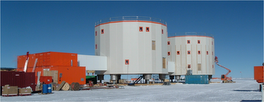
The French-Italian station Concordia sits in the heart of the Antarctic plateau, on the site of Dome C, and at an altitude of 3233 meters of which more than 3200 meters are made of ice. It is a unique place, totally devoted to sciences. The 3270 meter ice-core project Epica permitted the decryption of up to 800 000 years of past climate. Other activities are in development at the site. The CNRS-Images team has followed the astronomers and the seismologists during their labors. At the start of February, the doors of Concordia will close to the summer technicians and researchers. Only 13 over-winterers will remain, both French and Italian. They will be there almost 10 months, far from everything, out of time, in this world of extremes.

-----
Keep up to date with the latest developments at http://sismordia.blogspot.com

Tuesday, June 3, 2008

Blogging hiatus is over

Apologies to my regular readers for the prolonged blogging hiatus. I have been somewhat absent from the whole blogging world for the past couple of months. It proved to be too difficult to blog from my last field-trip, and I have been working hard on a paper since getting back last month (the paper was submitted a few days ago, details soon).

In the meantime, a lot has been going on regarding CASE-IPY and other seismology at Concordia:

  • The stations we installed during the last Antarctic field trip (CASE01, CASE02, CASE03) have now all gone to sleep for the duration of the Antarctic winter. The updated state of health plot for the stations shows that the longest running station CASE03 went into hibernation on April 18th. Bets are open as to when the first station will awaken in the spring.
  • The permanent station CCD is running nicely, with both the heated and the unheated seismometers performing well. You can look up the state of health for the station, as well as journal plots for the data and snapshots of events (including the recent M7.9 Sichuan earthquake) on the Concordia Seismology website.
  • We are planning both the 2008-2009 and the 2009-2010 summer campaigns at Concordia. The first campaign will be dedicated to recovering the full data from the CASE prototype stations, re-installing these prototypes for a second year of measurement, and upgrading the permanent station (CCD). We hope to stay longer than two weeks at Concordia this time, which should give us enough time to complete the essentials of the campaign and run a number of extra tests. The 2009-2010 campaign will be dedicated to installing 7 new autonomous seismic stations between Concordia and Vostok. Given the logistical constraints on the transport of all the material required for this deployment, we are building the stations this year. They will be shipped to Antarctica in the fall, will over-winter at Dumont d'Urville station, and will travel up to Concordia on the first land transport of the 2009-2010 season.
All in all, plenty to keep me busy and out of mischief! Now that my work load has simmered down to manageable proportions again (!), you can expect to see more of me in the blogging arena, and specifically many more Sismordia posts.


-----
Keep up to date with the latest developments at http://sismordia.blogspot.com

Sunday, April 6, 2008

Using seismic waves to image Earth's internal structure

ResearchBlogging.org

Life on board the Marion Dufresne continues uneventfully. I am taking advantage of the relatively clement sea conditions to work on a manuscript due for submission soon, and to read some scientific literature.

Earth science is a frustrating subject at times. It seems the more we investigate the Earth, the less we understand how it works. Controversy is rife, generating much confusion in the minds of students and researchers alike. Questions like 'How do subduction zones work?' and 'Where does hotspot volcanism originate?' are still hotly debated at international conferences and in print. One of the ways we are trying to address these open questions is by striving for clearer and higher resolution images of the Earth's interior.

Romanowicz (2008) gives a good three-page summary of past progress and outstanding issues in the use of seismic waves for this type of imaging.

To address these controversies, seismology has been brought to bear to image Earth's deep interior. From the construction of accurate models of Earth's one-dimensional radial structure to the current models of its three-dimensional structure, progress in seismic imaging has gone hand in hand with improvements in the design of seismic sensors, the capacity to record digitally increasingly massive quantities of data, theoretical progress in handling seismic-wave propagation through complex three-dimensional media and the development of powerful computers for simulating seismic waves and for the inversion of large matrices.
We are now at a point where there is a certain consensus regarding the long wavelength heterogeneities within the Earth. The next steps according to Romanowicz should be
characterizing the sharpness or fuzziness of the boundaries of the heterogeneous structures deep inside the planet, and detecting and mapping small-scale heterogeneity [...] This will mean extracting more information from seismograms than has traditionally been done.
Romanowicz goes on to describe some of the recent advances that are already leading to improvements in tomographic imaging techniques, including first order scattering theory, spectral element wavefield simulation methods and the extraction of structural information from the cross-correlation of noise records.

The problem of data coverage still remains:
A significant challenge is the limited distribution of seismic-wave sources and receivers. Ideally, one would want to sample the volume of Earth uniformly. But unlike other disciplines that use imaging, such as medical tomography or petroleum exploration, earthquake seismologists cannot optimize their experimental geometry.

Here we return the main theme of the last few research blogging posts: the need to obtain more raw data and to exploit them more fully to improve the imaging of Earth's interior.

Quoted text reprinted by permission from Macmillan Publishers Ltd: Nature, copyright (2008).

References

Romanowicz, B. (2008). Using seismic waves to image Earth's internal structure. Nature, 451(7176), 266-268. DOI: 10.1038/nature06583

Saturday, April 5, 2008

Life on board the Marion Dufresne

No two field trips are alike, not even when they take you to exactly the same sites. A lot of the atmosphere of such a trip is created by the participants, the rest is determined by the weather, and neither element can be influenced.

I first went on this trip to the French Austral Islands two years ago, and for me it was a voyage of adventure. I had only recently started a new job, was traveling alone, and had only a vague idea of what was going to happen. This second time round, the trip has a cozy and familiar feel to it. I know the ship (the Marion Dufresne is a luxury cruise liner compared to the Astrolabe), I know how life on the scientific bases of the sub-Antarctic works, there are many familiar faces amongst the passengers and the crew, and I shall be meeting more people I know on the bases themselves.

There are few scientists on this leg of the voyage (more will come aboard as we pick up the last of the summer campaigners on each island). Most of the passenger list is made up of logistics people, with the addition of a few tourists. The Marion Dufresne regularly takes tourists along on these trips. They get to visit the bases and talk to the scientists, and they also visit a number of protected sites elsewhere on the islands with a specialized tour guide. The trip is not cheap, and apparently there is a year long waiting list for the few available slots. The people who come are usually highly motivated and curious about all aspects of the sites and of the science that is being done there. They learn more about the islands and what is being studied there than we do, given that we spend most of our time working on our respective projects.

We got treated to a fantastic spectacle last night, courtesy of a late summer storm. The heat and humidity that had been mounting throughout the day finally gave way to thunder and lightening. We stood outside on the covered deck, with the rain drumming down on all sides and sloshing off the top deck, gasping at the sight of the mauve sky and mauve ocean suddenly revealed then immediately hidden again. Truly a breathtaking sight.